The Santiaguito is actually a sub-volcano of the Santa Maria Volcano in western Guatemala. The main volcano rises near the city of Quetzaltenango 1400 meters above the highlands of Guatemala. In 1902, the flank of Santa Maria ruptured and a plinian eruption produced slag and ash for 19 days, killing 5000 people. The eruption cloud reached a height of 27 kilometers.
The eruption is one of the strongest eruptions of the 20th century and its intensity is comparable to that of Pinatubo 1991. Initially a lateral crater had formed on Santa Maria, in which a dome has been growing since 1922. This dome has grown to a separate volcanic cone, the Santiaguito. In the meantime, four generations of domes can be distinguished. The domes are made of andesite, a highly viscous type of lava typical of volcanism in subduction zones.
Pictures of Santiaguito volcano
At the turn of the year 2009 I visited the volcanic complex in Guatemala. Not very pleasant was the fact that the airline Iberia lazed my luggage and I had to wait 3 days for it. In order not to be completely idle, I borrowed the most necessary things from a local tour operator Caminando Guatemala to spend the New Year's Eve on the mountain. Unfortunately no tripod could be found, so I could neither film nor photograph properly.
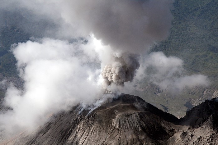
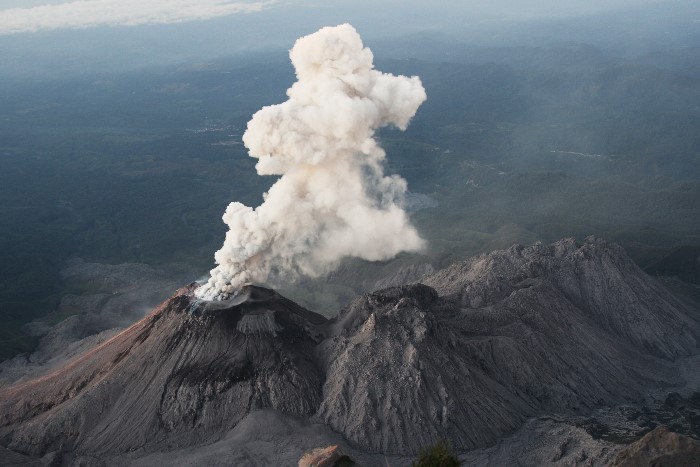
I climbed the volcano together with Martin Rietze, for whom it was the 4th stay at Santiaguito. We spent the turn of the year on the flank of the Santa Maria at the height of the domes, where we had a very good view. After my luggage had arrived we climbed the volcano the same evening. The ascent turned out to be exhausting due to the high altitude, but it didn't require any special mountaineering skills, as the path is well developed. We spent 3 nights on the summit of Santa Maria. Despite the proximity to the equator we had night frost. The eruptions came in intervals between 40 minutes and 3 hours and started practically without warning. The peculiarity of the Santiaguito is that at the beginning of the eruption the ash is pushed out of the dome in a ring shape. Photographically it is a challenge to document this initial phase. On some shots in the video clip the initial phase can be seen very nicely.
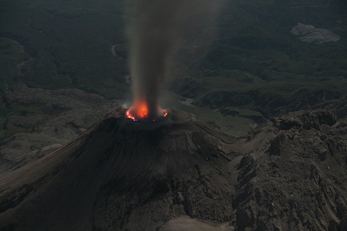
Red heat is only faintly visible to the naked eye during night-time eruptions and only becomes clearly visible in long-exposed images.
The descent turned out to be somewhat more complicated than the ascent. Since the ground froze at night and began to thaw in the morning, a thin film of mud formed on frozen ground, making the whole thing very slippery.